


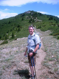
 John Brewer and I finally got to do the South Peak hike today that we've been talking about for some time. It turned out to be a pretty brutal route. We started at Canyon Estates up near the village of Tijeras, hiking up the South Crest Trail to the junction with the Upper Faulty Trail, which also marks the beginning of the CCC "route," an extremely steep trail that traces a pretty direct path to the South Peak area. That took a lot more out of me than I expected, as I was having to stop every 75-100 yards to let my heart rate go down. The Sandia hiking guide says that CCC "route" is only 1.8 miles from end to end, but John and I have a running joke going about "Forest Service miles" and how they always seem to understate the actual distance. (Anyone who's read Norman Maclean will know what I'm talking about.) From there we hiked up to South Peak, where we ate lunch and then dropped down off the back through the hidden little canyon there that has a thick stand of aspens. Then we descended the west side of the mountain, taking the Embudito Trail to Oso Pass and then heading west on the ridge route (or "Whitewash" Trail) all the way down to the top of Menaul Blvd. In many ways, the hike down was almost as hard as the hike up the back side, but we wanted a challenging hike and definitely found one; however, in the end I had a great time. The photos above show (a) me striking an heroic pose on South Peak, (b) the view northwest from South Peak, (c) me in the aforementioned aspen grove just off the back side of South Peak, and (d) John on the spur trail leading to South Peak.


 John Brewer and I finally got to do the South Peak hike today that we've been talking about for some time. It turned out to be a pretty brutal route. We started at Canyon Estates up near the village of Tijeras, hiking up the South Crest Trail to the junction with the Upper Faulty Trail, which also marks the beginning of the CCC "route," an extremely steep trail that traces a pretty direct path to the South Peak area. That took a lot more out of me than I expected, as I was having to stop every 75-100 yards to let my heart rate go down. The Sandia hiking guide says that CCC "route" is only 1.8 miles from end to end, but John and I have a running joke going about "Forest Service miles" and how they always seem to understate the actual distance. (Anyone who's read Norman Maclean will know what I'm talking about.) From there we hiked up to South Peak, where we ate lunch and then dropped down off the back through the hidden little canyon there that has a thick stand of aspens. Then we descended the west side of the mountain, taking the Embudito Trail to Oso Pass and then heading west on the ridge route (or "Whitewash" Trail) all the way down to the top of Menaul Blvd. In many ways, the hike down was almost as hard as the hike up the back side, but we wanted a challenging hike and definitely found one; however, in the end I had a great time. The photos above show (a) me striking an heroic pose on South Peak, (b) the view northwest from South Peak, (c) me in the aforementioned aspen grove just off the back side of South Peak, and (d) John on the spur trail leading to South Peak.