|
| Aztec Motel - Before Demolition |
 |
| Aztec Motel - During Demolition |
 |
|
|
|
| Central Ave. in September 1963 |
I've always felt a vaguely romantic attachment to Route 66 (John Steinbeck's "Mother Road") and the role it played in the westward migration of Americans from the 1920s on through the 1960s, or when the Interstate highway system came of age. I've never really understood the evolution of Route 66, although I know that at various stages it had some weird, round-about deviations on its way through New Mexico -- a prime example being that it once went down Isleta Blvd. in the South Valley, and on south to Los Lunas, before it angled northwest and headed toward Grants, Gallup, and the Arizona border. My father drove bus for Greyhound for some 37 years, and he spent most of that time driving back and forth between Albuquerque and Flagstaff along a very desert-y stretch of Route 66 (and later I-40). He could say without exaggeration that he knew every bump in the road.
Before the creation in 1962 of the first freeways in Albuquerque, the primary east-west artery through town was Central Avenue -- US 66 -- along which can still be seen various old motels, storefronts, and even filling stations that date to that era. Obviously, over time the construction of I-40 sounded the death knell for Central as a stopping-off place for interstate travelers (except for its motel-dotted far-east end, where it intersects with Tramway Blvd. near I-40 -- which intersection is now a prime gathering point for transients with few means and sometimes-running cars); however, even today one can almost feel the presence of ghosts from bygone decades as one drives along East Central. Most of the old Route 66 motels became fleabags wherein prostitutes often plied their trade, but it's difficult for any long-time resident of Albuquerque not to feel fond of these motels and wish for their preservation. Thus it was with some sadness that I read recently about the razing of the Aztec Motel, which, in addition to being an old Route 66 motel, had become a landmark for another reason: the plastering on its walls of various bottles, hubcaps, and other neighborhood detritus that lent it an eccentric charm all its own. The two photos above of the Aztec show it prior to its end and as the demolition was commencing.
The third photo is taken from my high school's 1964 yearbook and shows the school's marching band in the State Fair parade in September 1963 (i.e., two-plus months before the JFK assassination). In the photo, the band is heading west along Central, probably in the vicinity of Louisiana Blvd. It's fascinating to see what even a small segment of Central looked like in the early 60s! Note the "US 66" road sign, the old motel and Shamrock gas station in the background, the presence of what must have been (at that time) very stylish late-model cars, and the sign advertising a pizza joint one mile east. (My mother always took us to see the State Fair parade -- and thus I probably watched this very parade at the age of four -- although we generally parked somewhere near the Fair Plaza shopping center [what we would now call a strip mall] and watched as the parade winded back east along Lomas Blvd.)
The National Park Service has a website on the history of Route 66 that contains various historical photos of sites on New Mexico. I plan to read all of it soon.
[Update 7/8/11: The NPS website notes that it was in 1937 that Route 66 was significantly shortened, by 100+ miles, as it passed through New Mexico. Prior to that time, the route took a big "S" through the state, heading northwest from Santa Rosa and coming back through Santa Fe, then passing through Albuquerque in a southerly direction to Los Lunas and then going northwest to the Laguna Pueblo, where it finally turned west again. (The highway segment that connected Los Lunas and Laguna still exists, although for a long time I thought it to be of recent vintage, presuming it was built to allow judges and other public officials to drive back and forth between Grants and Los Lunas -- which are county seats located in the same judicial district -- without having to go through Albuquerque. I'm sure that savvy people still use it to bypass Albuquerque, if they're south of town and want to go west, or if they're west of town and want to go south.) Thus Central Avenue became part of Route 66 in 1937 and then all the motels started springing up.]
 |
| Me at Echo Amphitheater, 1963 |
[Update 1/30/12: Here's a picture of me in almost the exact time-frame in which the "State Fair parade" photo above was taken (when I was four years old). We were at Echo Amphitheater, located between Abiquiu and Tierra Amarilla in northern New Mexico. (Inasmuch as my family went to Echo Amphitheater in 1963 at about the same time we went to El Morro National Monument, for years I conflated the two in my mind. It wasn't until we finally went back to Echo Amphitheater, around 1976, that I was disabused of the notion that Echo Amphitheater had a large, spooky green pool of water -- whereas El Morro, as I knew by then, did have such a pool.) Ironically, nowadays we pass by Echo Amphitheater every time we go to the cabin (which is near Pagosa Springs, CO), although we haven't bothered to stop there in a number of years.]
 |
| Western Skies Hotel, ca. 1959 |
[Update 5/26/12: This aerial photo comes from an old postcard I bought on the Internet. It shows the Western Skies Hotel -- the last (and easily the greatest) of the Route 66 lodges to go up in Albuquerque before the advent of I-40 -- which used to be located at the far eastern end of Central Avenue. (Route 66 is the divided highway at the bottom right.) The hotel, which opened in early 1959 according to contemporaneous newspaper articles, was still there when I was in high school; I think it was torn down sometime in the early 1980s. It once must have been considered the nicest hotel in Albuquerque, as President John F. Kennedy and his wife Jackie stayed there when they came to town in December 1962. In fact, when I was a senior in high school (in the fall of 1976), I liked a girl in our ward named Peggy C____, who actually lived for a time in the Western Skies presidential suite with her family. (I remember the door still bore a plaque stating that JFK had stayed there.)
 |
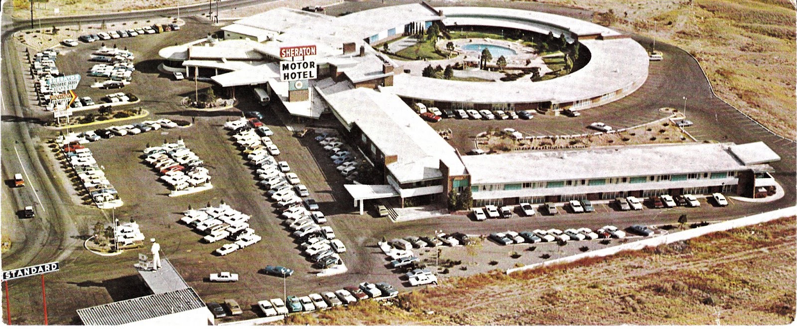
| Sheraton Western Skies, ca. 1970 |
Here's a second view of the Western Skies, circa 1970, by which time Sheraton had bought out the original owners. (Note the lighter-colored roof and the mascot atop the adjacent Standard station.) There is now a Smith's grocery store where the Western Skies once was located.]
[Update 6/3/12: Here's a current-day Google Earth view of the eastern end of Central Ave. The Smith's store -- the former site of the Western Skies -- is the large white-roofed building just right of and below the center of the image. There is still a gas station across the street, where the Standard station appears in the vintage-1970 photo above. Note where Central diverges from I-40; the curving road going north, passing under I-40, is Tramway Blvd.]
[Update 10/25/15: Here is a cool photo of Central Avenue, circa 1970, looking east from Carlisle Blvd.]