Thursday, August 11, 2011

Camping Trip to Villanueva, August 5-6, 2011

Devery, Mason, Darren
Kayla and Tyler
Kayla, Tyler, and Mason at the playground
Dion at the playground
Tyler, Kayla, and Heidi
Breakfast
At the playground
On the main road through the park
On the bridge crossing the Pecos
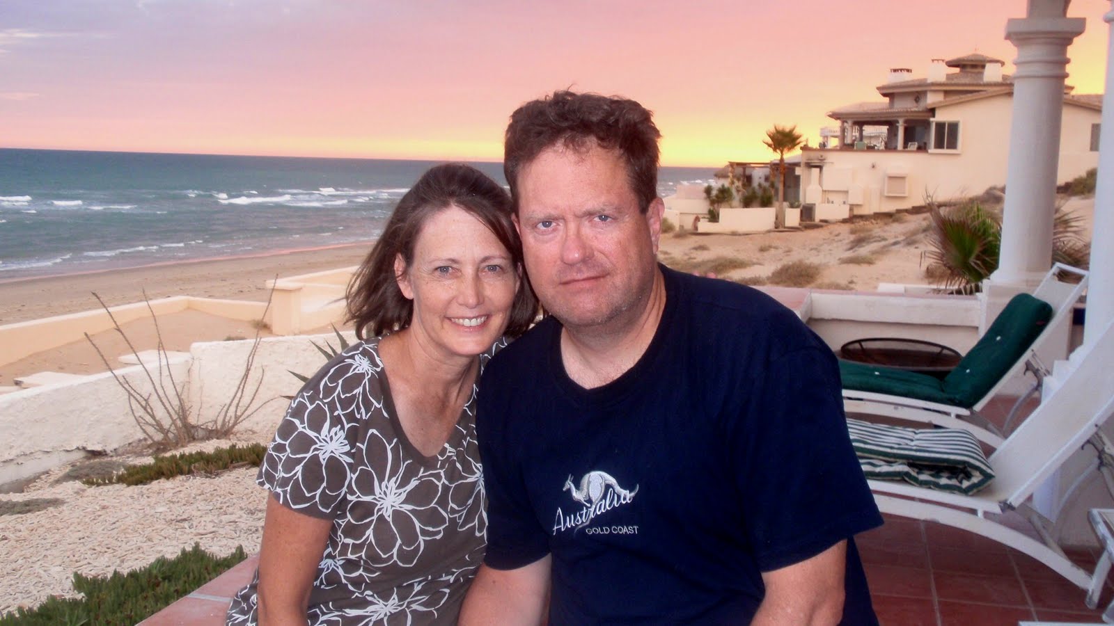
Dorine and I

These photos (and the video) are from our one-night camping trip to Villanueva State Park, New Mexico, on August 5-6, 2011.  We went with Heidi and her husband Dion (and their kids Kayla and Tyler), and with Devery and her little boy Mason.  We pulled into the park early on Friday afternoon, just as the camping spots along the river were filling up, and immediately the lady in the site next to us warned us of nocturnal bear activity and strongly advised us not to spend the night in tents.  However, we, never camping more than a couple of nights a year, only have tents (or "white trash trailers," as Dion calls them) for camping, and we certainly didn't drive all the way out there not to spend the night, so we ignored the warning.  (I also got the distinct impression that the lady was a little bugged about having little kids in close proximity and would say anything to get them to go away.)

Anyway, we did spend the night and, fortunately, weren't bothered by the juvenile black bears that, per the ranger, had been overturning trash cans every night.  Our campsite was very fortuitously located across the road from the park playground, and the kids all had a great time playing on the various slides, monkey bars, and other jungle-gym equipment there.  Villanueva has become sort of like our "family camping spot," even though we only go there once a year; the combination of accessibility (while still being off the beaten path) and physical features (Pecos River, hiking trails, and hills) makes it ideally suited for our purposes.  If I had my way, all of our trips there would be for two nights instead of just one, but "one" beats "none"!  I'm hoping to get in a second camping trip in October down at White Sands National Monument and Oliver Lee Memorial State Park, both of which are near Alamogordo, New Mexico, and perhaps we'll even get in a second night down in Carlsbad so that we can take the kids to see the Caverns.

Saturday, July 30, 2011

Mexico Trip, July 19-24, 2011

Casa Alhaja
Devery and Dorine in the living room
Darren out back on the stairs to the beach
Devery with Mason
Lounging at the waterline
Darren with gulls and pelicans
At Flavio's Restaurant
Easton, Steve, and Mason after getting ice cream
Downtown Puerto Penasco
In real waves
Dorine and I at sunset
Our part of the contingent
Front of the house
These photos are from our trip to Puerto PeƱasco, Mexico on July 19-24, 2011.  Our son-in-law Easton's parents, Steve and Jeannie H_____, invited us back down this summer.  I'm no big fan of the beach, not even having seen the ocean until I was 17 years old, and, even now, loathing even the slightest taste of seawater.  However, Casa Alhaja, the beachfront house (in the Las Conchas district of Puerto PeƱasco) of which the H_____s are part-owners, is a great place to spend a vacation -- especially if one stays for free as the H_____s' guests!  (The H_____s also invited Jeannie's friends Brian and Lisa Keltner, and their kids, from the L.A. area.)  I always worry about driving into Mexico, what with all the border-town crime going on in places like JuĆ”rez, Nogales, and Tijuana; however, if there is still a "safe" corridor into Mexico, it is the drive to Puerto PeƱasco via Lukeville/Sonoyta, as the area depends greatly on tourism to fuel the local economy.

The worst part of a trip from Albuquerque to Puerto PeƱasco is the long drive -- eleven hours' worth each way.  We drove down to Tucson on the evening of Tuesday, July 19, and spent what was left of the night in a Super 8 motel.  The next morning we drove on to Puerto PeƱasco, and then stayed there until Sunday, July 24, when we drove the entire way back to Albuquerque.  We had a fun time, and I enjoyed our forays into town to shop (both for food and for souvenirs) and to eat at Flavio's Restaurant (and then to get ice cream at La Michoacana).  The weather was hot, but at least the Gulf of California was right there to cool off in. 
Tuesday, July 5, 2011

July 2011 Cabin Trip

On the banks of the Rio Blanco
The blinds we installed in the living room
Rafting on the San Juan with a guide
These photos are from our trip to the cabin on July 2-5, 2011 with Kristy and Chris and their family.  Dorine and I didn't drive up to Pagosa Springs until Saturday evening the 2nd, partly because we needed time to buy blinds at Home Depot to install in the cabin's living room.  We were able to obtain the blinds and install them (see photo), although more are needed.  Three things stand out about the trip: (1) Nicole's suffering horribly from what turned out to be a post-operative infection in her small intestine; (2) our going into town on the evening of Monday the 4th to watch the fireworks display (which, I must say, was pretty impressive for a relatively small town); and (3) our paying for a guided raft trip down several miles of the San Juan River through town (see photo), which was significantly more fun than I expected it to be.  Pagosa Springs is a jewel of a town, but don't tell anyone I said so, okay?

Sunday, June 26, 2011

My Daughter Kiley's Wedding

Sam and Kiley, 6/24/11
My daughter Kiley was married to Sam H____ in the Albuquerque LDS Temple on Friday, June 24, 2011.  Theirs was a whirlwind romance, commencing shortly after (a) Sam arrived home from his church mission to northern Chile last fall, and (b) they met at the LDS Institute of Religion near the University of New Mexico campus in Albuquerque.  (The men in Sam's family traditionally waste no time in getting married after their stints as missionaries.)  Kiley was very young -- 19 in March -- for marriage, but the match is a good one and I have no doubt that Sam will care and provide well for her.  Kiley made a beautiful bride in the custom-designed dress that we engaged Erin M_____ (our bishop's wife) to make for her.  Sam, whose mother Celestine is one-half Japanese, will bring some Asian ancestry into our family, which I think is totally cool.

Do I feel regrets at "losing" our "baby"?  Perhaps a couple.  One, any familial upheaval in my current state of (un)health is more than a little difficult for me to bear.  (I've already sort of latched on to Kiley's dog Mischa -- whom we're now being landed with a second time -- as a surrogate for Kiley.)  And two, I feel wistful that Kiley and Sam have decided she will attend school at the local community college this fall instead of continuing at UNM.  (I can understand their reasoning in light of the extremely stressful -- if ultimately successful in terms of GPA -- freshman year Kiley had as a music major at UNM, which was made much worse by the distractions of becoming engaged and planning a wedding.  However, I still hope she'll go on to earn a four-year university degree, even if she never has to support them or even work full-time.)

[Update: Kiley did ultimately decide to remain at UNM, although she's changed her major to Family Studies.]

Wednesday, June 22, 2011

Looking at the World Through Sh%#-stained Glasses

I find myself sinking further down all the time; my outlook on life is so negative now that I find no cause for optimism or happiness in anything.  I can't help dwelling on the changes of the last two years -- two years ago, I had a sleep disorder and was dependent on prescription sleep meds, true, but I had no crippling illnesses and my job was tolerable.  I had no idea what a simple vacation, followed by a change of manager and new job responsibilities -- and now my having developed a tolerance for heretofore-effective sleep medications -- could do to my life, but the combined effect has been horrible.  None of my loved ones, friends, or acquaintances knows, or can know, what I'm going through.  A recent conversation with one of my brothers made me realize that most people, facing my afflictions and the resulting inability to bear even a moderate amount of physical or emotional stress, simply couldn't function at all; however, it's small comfort that I can still do so at some diminished level of rapacity...er, capacity.

[Update 6/29/11: I received word this week that a former co-worker of mine dropped dead from a massive heart attack last Saturday, the day his family had planned to have a party to celebrate his son's college graduation.  (I'm reminded that my father died on our oldest daughter's wedding day in 1997.)  I wonder if I could be next in line for the same or a similar fate.]

Friday, June 17, 2011

The Mother Road

Aztec Motel - Before Demolition
Aztec Motel - During Demolition


Central Ave. in September 1963
I've always felt a vaguely romantic attachment to Route 66 (John Steinbeck's "Mother Road") and the role it played in the westward migration of Americans from the 1920s on through the 1960s, or when the Interstate highway system came of age.  I've never really understood the evolution of Route 66, although I know that at various stages it had some weird, round-about deviations on its way through New Mexico -- a prime example being that it once went down Isleta Blvd. in the South Valley, and on south to Los Lunas, before it angled northwest and headed toward Grants, Gallup, and the Arizona border.  My father drove bus for Greyhound for some 37 years, and he spent most of that time driving back and forth between Albuquerque and Flagstaff along a very desert-y stretch of Route 66 (and later I-40).  He could say without exaggeration that he knew every bump in the road.  

Before the creation in 1962 of the first freeways in Albuquerque, the primary east-west artery through town was Central Avenue -- US 66 -- along which can still be seen various old motels, storefronts, and even filling stations that date to that era.  Obviously, over time the construction of I-40 sounded the death knell for Central as a stopping-off place for interstate travelers (except for its motel-dotted far-east end, where it intersects with Tramway Blvd. near I-40 -- which intersection is now a prime gathering point for transients with few means and sometimes-running cars); however, even today one can almost feel the presence of ghosts from bygone decades as one drives along East Central.  Most of the old Route 66 motels became fleabags wherein prostitutes often plied their trade, but it's difficult for any long-time resident of Albuquerque not to feel fond of these motels and wish for their preservation.  Thus it was with some sadness that I read recently about the razing of the Aztec Motel, which, in addition to being an old Route 66 motel, had become a landmark for another reason: the plastering on its walls of various bottles, hubcaps, and other neighborhood detritus that lent it an eccentric charm all its own. The two photos above of the Aztec show it prior to its end and as the demolition was commencing.

The third photo is taken from my high school's 1964 yearbook and shows the school's marching band in the State Fair parade in September 1963 (i.e., two-plus months before the JFK assassination).  In the photo, the band is heading west along Central, probably in the vicinity of Louisiana Blvd.  It's fascinating to see what even a small segment of Central looked like in the early 60s!  Note the "US 66" road sign, the old motel and Shamrock gas station in the background, the presence of what must have been (at that time) very stylish late-model cars, and the sign advertising a pizza joint one mile east.  (My mother always took us to see the State Fair parade -- and thus I probably watched this very parade at the age of four -- although we generally parked somewhere near the Fair Plaza shopping center [what we would now call a strip mall] and watched as the parade winded back east along Lomas Blvd.)

The National Park Service has a website on the history of Route 66 that contains various historical photos of sites on New Mexico.  I plan to read all of it soon.

[Update 7/8/11: The NPS website notes that it was in 1937 that Route 66 was significantly shortened, by 100+ miles, as it passed through New Mexico.  Prior to that time, the route took a big "S" through the state, heading northwest from Santa Rosa and coming back through Santa Fe, then passing through Albuquerque in a southerly direction to Los Lunas and then going northwest to the Laguna Pueblo, where it finally turned west again.  (The highway segment that connected Los Lunas and Laguna still exists, although for a long time I thought it to be of recent vintage, presuming it was built to allow judges and other public officials to drive back and forth between Grants and Los Lunas -- which are county seats located in the same judicial district -- without having to go through Albuquerque.  I'm sure that savvy people still use it to bypass Albuquerque, if they're south of town and want to go west, or if they're west of town and want to go south.)  Thus Central Avenue became part of Route 66 in 1937 and then all the motels started springing up.]

Me at Echo Amphitheater, 1963
[Update 1/30/12: Here's a picture of me in almost the exact time-frame in which the "State Fair parade" photo above was taken (when I was four years old).  We were at Echo Amphitheater, located between Abiquiu and Tierra Amarilla in northern New Mexico.  (Inasmuch as my family went to Echo Amphitheater in 1963 at about the same time we went to El Morro National Monument, for years I conflated the two in my mind.  It wasn't until we finally went back to Echo Amphitheater, around 1976, that I was disabused of the notion that Echo Amphitheater had a large, spooky green pool of water -- whereas El Morro, as I knew by then, did have such a pool.)  Ironically, nowadays we pass by Echo Amphitheater every time we go to the cabin (which is near Pagosa Springs, CO), although we haven't bothered to stop there in a number of years.]

Western Skies Hotel, ca. 1959
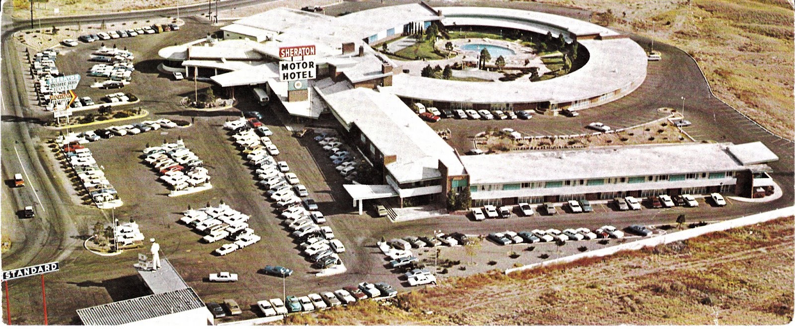
[Update 5/26/12: This aerial photo comes from an old postcard I bought on the Internet.  It shows the Western Skies Hotel -- the last (and easily the greatest) of the Route 66 lodges to go up in Albuquerque before the advent of I-40 -- which used to be located at the far eastern end of Central Avenue.  (Route 66 is the divided highway at the bottom right.)  The hotel, which opened in early 1959 according to contemporaneous newspaper articles, was still there when I was in high school; I think it was torn down sometime in the early 1980s.  It once must have been considered the nicest hotel in Albuquerque, as President John F. Kennedy and his wife Jackie stayed there when they came to town in December 1962.  In fact, when I was a senior in high school (in the fall of 1976), I liked a girl in our ward named Peggy C____, who actually lived for a time in the Western Skies presidential suite with her family.  (I remember the door still bore a plaque stating that JFK had stayed there.)

Sheraton Western Skies, ca. 1970
Here's a second view of the Western Skies, circa 1970, by which time Sheraton had bought out the original owners.  (Note the lighter-colored roof and the mascot atop the adjacent Standard station.)  There is now a Smith's grocery store where the Western Skies once was located.]

[Update 6/3/12: Here's a current-day Google Earth view of the eastern end of Central Ave.  The Smith's store -- the former site of the Western Skies -- is the large white-roofed building just right of and below the center of the image.  There is still a gas station across the street, where the Standard station appears in the vintage-1970 photo above.  Note where Central diverges from I-40; the curving road going north, passing under I-40, is Tramway Blvd.]

[Update 10/25/15:  Here is a cool photo of Central Avenue, circa 1970, looking east from Carlisle Blvd.]

Saturday, June 11, 2011

HIke to South Sandia Peak

Our Route - clockwise loop, starting from lower right
I took my "killer" hike yesterday up to South Sandia Peak with Darren and John Brewer.  We started at Canyon Estates (in/near the village of Tijeras, east of Albuquerque), hiking on the South Crest Trail all the way to the upper terminus of the Embudito Trail, then making our way up to South Sandia Peak, and finally hiking down the "CCC Route" to its lower terminus and then back to our starting point.  I wasn't sure how I'd do, but I hung in pretty well; in fact, when the hike was over, it seemed like getting up to South Peak was the easy part, whereas hiking down the extremely steep "CCC Route" took a much-greater toll on me. (Two years ago, John and I hiked up the "CCC Route" on our way to South Peak; I wonder now how I did it, except that my health was better then.)  The only disappointment of the day was arriving at South Sandia Spring and finding it dry; I'd taken along a water filter for the express purpose of having a nice drink of cold spring water, but to no avail.

Anyway, given that I'd wondered if I'd ever see South Peak again, it was especially gratifying to be there and then to hike off the back of the Peak through the cool little canyon and aspen grove there.  I have to say now that South Crest is probably the easiest route to get to South Peak; it's certainly less difficult than any route on the west side of the Sandias.  I can't say what other "long" hikes I'm capable of -- I'm definitely having second thoughts about ever hiking up Chimney Canyon again -- but hiking up and back down the La Luz Trail proper is feasible.

Darren on the South Crest Trail
John in the Aspen Grove East of South Sandia Peak
Darren and I on the South Crest Trail
[Update 6/13/11: I've realized that this map also contains the site of Darren's 2005 Eagle Scout service project -- Carlito Spring, which is just to the southwest of Canyon Estates as the crow flies.]

[Update 6/14/11: I remember that the young men/scouts from our ward spent two nights at Deer Pass, just west from where the Embudito Trail cuts off South Crest, in April 2001 (see the unfortunately fuzzy photo below, taken at South Peak).  Chad Twitchell hiked with the older boys, who were training for their trip to the Philmont Scout Ranch that summer, with full packs all the way from our church building on Indian School Rd. to Deer Pass via Embudo Canyon. (Brutal!)  John Brewer and I took the younger boys (including Darren and John's son Steven) up the CaƱoncito Trail on the east side of the range, then south on the Crest Trail, meeting up with the others near Deer Pass.  We had to decide whether to camp on the meadow just south of South Peak or at Deer Pass; ultimately we chose the latter, which turned out to be a wise decision, and for a very simple reason: it put us that much closer to South Sandia Spring, the only source of water in the vicinity.  The spring was still over a mile away, and I can remember having to shuttle down there four or five times for water while we were camped at Deer Pass.  If the spring had been dry then like it was last Friday, we'd have been hurting.  In this photo (taken by Chad Twitchell): Jordan Roper, Steven Brewer, John Brewer, Landon Roper, Rob Pulsipher, Brandon Schofield, David Griffin, me, Brent Phelps, Lance Schofield, Michael Griffin, Curtis Twitchell, Paul Twitchell, and Darren Kartchner.  (Darren and I are the ones with the blue-camouflage boonie hats.)]
Troop 206 at South Sandia Peak, 4/13/01
[Update 6/19/11: Due to the perceived fire hazard caused by the dry conditions this year, the Forest Service has now closed all the hiking trails in the Sandias for the rest of the summer and part of the fall.  I guess it was a good thing we didn't wait to take our South Peak hike.]

Monday, May 30, 2011

Hike to the Head of Whitewash Canyon

The South Foothills of the Sandia Mountains
I took another hike on Sunday, May 29, 2011, this time going by myself and starting at the far eastern end of Menaul Blvd. and taking what the guidebook calls the "Whitewash Trail" (which is sort of a misnomer inasmuch as it neither follows Whitewash [i.e., Piedra Lisa] Canyon nor is much of a trail).  I only intended to go as far as the first little promontory at the head of Whitewash Canyon, and I was able to ascend that high, although the weather was hot and the steepness of the route -- it gains 2,000' in elevation in two miles' horizontal distance -- had me huffing and puffing most of the way.  (The route passes through the site of a brush fire that happened a couple of months ago, which was reportedly caused by people lighting fireworks.)  The saving factor for me was the 25-30 mph wind that was blowing, which kept me pretty cool.  The map above shows both the route I took this week and the hike that Darren and I did last week to the "Eye of the Sandias."  (My next Sunday-afternoon hike will probably take me up Embudo Canyon, located in between my last two routes.)

Looking North
Looking South


[Update 6/6/11: I took a hike up Embudo Canyon yesterday afternoon. I started at the open space parking lot at the end of Indian School Rd. and hiked up past what I call "the narrows" into the wider eastern end of the canyon, turning around at the start of the rocky switchbacks that lead to the junction with the Three Gun Spring Trail. It was a pretty easy hike compared with the last two that I did, but "two miles up and two miles back" seems to be a pretty good length for a Sunday-afternoon hike.  I'll probably start moving north for additional hikes. Note that I have modified the attached illustration to add the Embudo Canyon route that I took yesterday.]

Sunday, May 22, 2011

Hike with Darren to the "Eye of the Sandias"


I've been telling my therapist (in the employee assistance program at work) for several weeks that I would start taking short hikes on Sunday afternoons, after church, just to be able to do something "healing" for myself every week.  (We'd discussed at length what I could do as a "restorative" measure, and hiking was about the only thing I could do regularly that wouldn't cost a lot of money.)  Unfortunately, I've found that it's much easier to stay on the couch than to get off it, particularly on Sundays -- and especially with the fatigue that my chronic dizziness causes -- so the psychologist, the internist, and the sleep tech had to gang up on me last week to shame me into going hiking, finally.  I'd picked out the first hike I wanted to do, which was to hike up to the "Eye of the Sandias," a "quirky landmark" mentioned in Mike Coltrin's Sandia Mountain Hiking Guide.  My brother-in-law Mike and I tried to find the "Eye" sometime back, but we got lost and finally turned around.  (We also weren't prepared for the difficulty of the hike -- the route is only two miles one-way, but it's very steep and loose in places.)  Anyway, Darren and I went and did the hike today (it's a good thing Darren went, as I would have become lost again otherwise); I had to stop a lot to catch my breath, but, really, I did surprisingly well, all things considered.  So well, in fact, that I think I can manage the next "killer" hike I'd like to do, which is to hike up the South Crest Trail to South Sandia Peak and then back down the "CCC" Route. The attached photos show me and Darren with the "Eye," which supposedly is a comment, first painted in the 1960s (and touched-up in 2002), on the encroachment of society on the Sandia Mountains.  (The Zia symbol in the "pupil" suggests a Native American origin or influence.)

[Update 10/24/11: I hiked up to the "Eye" again yesterday afternoon, this time by myself.  It was much easier to find the second time, although I'd already forgotten how long the hike was.]
Me and the "Eye"
View of I-40 from the "Eye"

Wednesday, May 18, 2011

Life Must Have Meaning

The other day I was reading about how Stephen Hawking, the eminent British physicist, referred to the concept of Heaven as a "fairy story."  One could understand why a scientist who has lived for so long with profound physical disabilities questions the existence of God and the notion of life after death.  What I question, however, is Hawking's follow-up statement to the effect that human beings should fulfill their potential by making good use of their lives.  To what end?  If life has no purpose, and no meaning independent of the here and now, who's to determine what any of us "should" do?  Indeed, it is my experience that people who don't believe in life after death generally become increasingly self-absorbed, heedless of the consequences of their actions to others, and much less likely to exhibit true charity.  They tend not to take on the responsibilities of marriage and parenthood -- they profess concern about the state of the world that the current population will leave to succeeding generations, but it's apparent to me that they don't really care about the future beyond their own demise.  As long as they get theirs in their lifetimes -- they seem to think -- and leave no progeny, why should they care about the prospect of economic/societal collapse and the civilized world's being sacked by the barbarians at the gates (or, worse, by the ones in our midst)?  The fact that these people see wispy bogeymen like "climate change" as bigger existential threats than the bankrupting of the federal treasury, or the possibility of some terror group's obtaining and detonating a nuclear weapon, speaks volumes about how basically whacked they are.

On the other hand, it's a little ironic that I write about life's needing to have purpose, given how little meaning I feel my life has at this paraje.  The truth is that my family members -- wife, kids, grandkids, mother -- are my life's purpose, and I bear significant burdens for them that aren't always apparent.  (Heck, just living with my mal de debarquement dizziness is sometimes more burden than I think I can tolerate.)  The reward is that occasionally I get to spend time with my loved ones in beautiful places, such as last weekend at "our" cabin in Colorado -- see the photo above of my grandson Mason on the road outside the cabin, taken on Saturday, May 14.

Sunday, May 8, 2011

My Colonoscopy

I had my "screening" colonoscopy on Friday, April 29; the immediate result of the procedure was that the doctor found two polyps on the "splenic flexure" (see attached photo), which he removed and sent to the lab for biopsy.  As I write this, I have yet to receive the pathology report, but, assuming neither polyp was pre-cancerous, I won't have to undergo another colonoscopy for ten years, assuming I live that long.

The worst part of the procedure, by far, was the "prep," which entailed certain dietary restrictions and mega-doses of laxatives.  During the last 24 hours before the colonoscopy (which, because my procedure was in the late morning, actually worked out to ~34 hours), I was restricted to a "clear liquid" diet, which in my case meant beef bouillon, chicken bouillon, popsicles (no red or purple), and (blue) Gatorade.  I had to take four Dulcolax tablets at noon on Thursday, which started the "flood," and then, after dinner, I had to drink 64 oz. of Gatorade mixed with 8.3 oz. of Miralax -- fourteen standard doses.  (The instructions called for me to drink 8 oz. of the Gatorade/Miralax mixture every fifteen minutes, but I actually drank it 12 oz. at a time and thus had it all down in 75 minutes.)  Needless to say, I spent a lot of time that evening on the john, although at least I didn't feel much abdominal discomfort.  I couldn't force myself not to take my sleep meds that night, which made me concerned about how they might "cloud" things the next day; however, the report said the quality of my bowel preparation was "good."

I'm told that a colonoscopy only qualifies as a "preventative" medical procedure, in insurance terms, if it doesn't turn up any polyps; therefore, I'm now expecting to have to pay for a sizeable share of it.  And now we've eliminated one more thing -- colorectal cancer -- as a contributing cause of my post-cruise dizziness; I only hope the pathology report comes back "clean" so that I don't have to go through this again in five years (again, assuming I live that long). 

[Update 5/13/11: The pathology report came back -- the two polyps were "adenomatous," meaning they had the potential to turn cancerous, but that there was no actual cancer.  I guess that puts me on the "five year" track for having another colonoscopy.  Crud!]